Geodata International


Complete database with geographic data for the whole world.
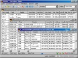
Geodata International is a splendid global database containing data from countries with georeferenced towns, municipalities, postal codes and administrative units, so you can track geocoding elevations, do proximity searches, navigation and distance calculation.
It's an ideal for those who need to find a distinct geographic location, the exact distance between two cities or know the postal code of a given site. In addition, for local businesses Geodata International can be used to indicate where is the nearest location, obtain statistics or view general maps of the area.
The distances between locations or post codes can be readily determined by the coordinates listed in the database tables. Geographical references are available on all databases in addition to UTM coordinates on the natural environment and the representation of meridians and geographical coordinates in degrees, minutes and seconds.
The Geodata International database can be downloaded in a trial version with some of the features mentioned above, so you can check if Geodata International is useful for your work or daily activity.
DownloadGeodata International related downloads
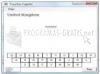
Theenk World Capitals 1.0.0.31
 Download
A geographic tool to learn the world's main capital cities and the US states.

Atlas of Britain and Ireland 1899
 Download
An impressive Atlas of Britain and Ireland from 1899 with colour maps.